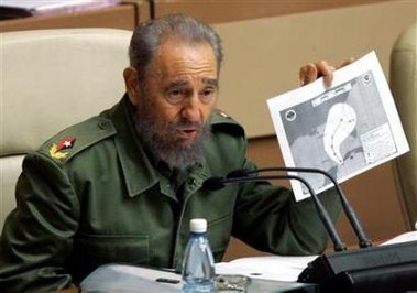
 Cuba's President Fidel Castro shows a print of a satellite image of Tropical Depression One over the Gulf of Mexico during a meeting of the Cuban National Assembly in Havana, June 10, 2006. (Claudia Daut - CUBA/Reuters)
I just love how Fidel Castro will rail against the U.S., but where does he turn for his weather information? Look closely at the Rueters Photo and tell me that you don't see something familar in the logos on the upper left and upper right corners of the map he is holding. I found it quite funny and ironic.
Hat tip to Yahoo! News.
3 comments:
I cannot read it it's too small, but I'm guessing its copyrighted by a corporate entity. Would they allow cuba to have their own sattelite?
I didn't correct the caption, but he is holding a forecast track map of the Tropical Depression one. However, the logos are the National Weather Service (the U.S. National Weather Service) and NOAA, the parent agency of the NWS.
look at the bastard eyes. does he get any sleep?
www.abajofidelblogspot.com
Post a Comment